
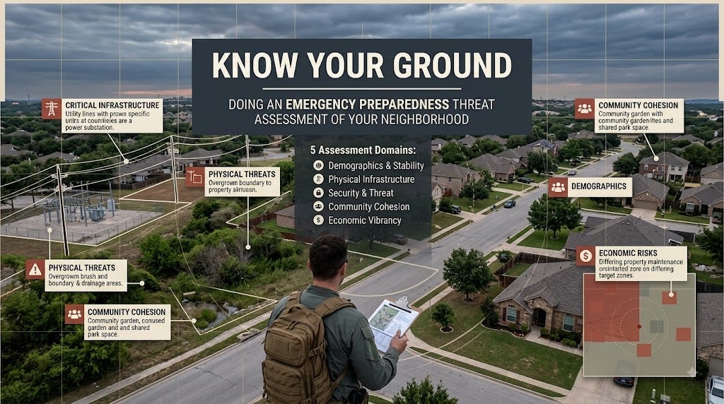
How a 25-year Army vet applies intelligence assessment to the place you call home
When I was in the Army, we had a standard: before you conduct operations in any area, you know it cold. Not as a tourist. Not as a commuter passing through. You map the terrain, the people, the infrastructure, the threats, the resources. You know which streets are blind, which neighborhoods support each other, which organizations actually have power, where the weak points are.
That methodology saved lives in Iraq. It kept units from walking into ambushes. It helped us identify real community leaders instead of whoever was most vocal. It showed us where we could help and where we’d make things worse by trying.
I’m retired from the Army now, but I didn’t retire from that habit of knowing the ground.
Your neighborhood is your operational area. And if you’re serious about emergency preparedness and family protection, you need to know it the way the Army taught me: with intentional, systematic assessment. Not paranoia. Not fear. Just clarity.
Most people don’t know their neighborhood at all. They know the route to work and the grocery store. They know a few neighbors by name. They couldn’t tell you the crime rate on their street vs. three blocks over. They don’t know what happens to water, power, or supplies if the roads get cut off. They’ve never thought about whether their community is stable or transient, whether people help each other in crisis or lock their doors and hope.
That gap is the one emergency preparedness has to close.
What Army Intelligence Assessment Looked Like
When the military assessed a new area of operations, we asked hard questions in five domains:
Demographics & Stability: Who lives here? Are they rooted or transient? What ethnic, religious, or cultural divides exist? Do people trust each other or are there real fractures?
Physical Terrain & Infrastructure: What’s the actual layout? Where are the bottlenecks? What keeps the area running—water, power, supply lines? What fails first when systems degrade?
Security & Threats: What’s the real threat picture? Where is it concentrated? What organizations—criminal, civic, governmental—have actual power? Where are the safe zones and the danger zones?
Community Leadership & Relationships: Who do people actually trust? Who can get things done? What’s the relationship between official leadership and community leaders? Will people follow orders or work with each other when things break?
Economic & Service Capacity: What keeps people fed and supplied? What services (medical, law enforcement, fire) are available? What happens to those services if demand spikes or supply gets interrupted?
That framework works for a neighborhood. It works for a city block. It works anywhere you need to understand a place well enough to survive and protect the people you care about.
Assessing Your Neighborhood: Five Questions That Matter
You don’t need a military intelligence team. You need one afternoon, some direct observation, and willingness to ask hard questions.
Demographics & Stability
Walk your street. Sit on the porch. Notice:
Are the same people living here long-term, or does the population churn every couple years?
What’s the age range? All young families? Mixed? Elderly? (This affects how people respond to crisis and who can help whom.)
Are there real ethnic, religious, or cultural divides, or is it mixed without tension?
How many properties are owner-occupied vs. rentals? (Owners tend to invest in community; renters tend toward transience.)
Are there homeless encampments or signs of heavy drug use? These are honest observations, not judgments—they affect safety and community response in crisis.
Why it matters: A stable, rooted neighborhood is more likely to self-organize in crisis. A transient neighborhood will have less mutual aid and more chaos. If half your neighbors will be gone in two years, they won’t help you weather a storm.
Physical Infrastructure
This one takes a small drive or walk.
Where does water come from? Is there only one main line into your neighborhood, or are there redundancies?
How many ways in and out? If the main road floods or gets cut off, what’s the alternate?
Where is the power infrastructure? (Look for transformer boxes, substations.)
Where are the gas lines, cell towers, internet infrastructure? One hit point or distributed?
Are there hospitals, fire stations, or police stations nearby? How far?
Where would supply chains get interrupted if transportation networks go down?
Why it matters: When infrastructure fails, you need to know how bad it gets and how long it lasts. A neighborhood with one road in is vulnerable to a single closure. A neighborhood dependent on one water main is vulnerable to a single break. If the nearest hospital is an hour away, you’d better have good first aid skills.
Security & Threat
This requires honest observation, not fear. Walk at different times of day. Drive different routes.
Where is the majority of crime concentrated? (Block-by-block crime maps exist for most cities—pull the data.)
What types? Property crime, violent crime, organized activity?
Do you see obvious gang markers? Active dealing?
Where are the safe pockets and the sketchy blocks?
How visible is police presence? Quick response or slow?
Are there any industrial facilities, railroad lines, or high-traffic corridors that bring crime nearby?
Why it matters: If you know where the crime is, you avoid it. More important: if something happens in your area, you’ll know whether to expect police quickly or whether you need to be more self-reliant.
Community Leadership & Relationships
This one is harder because it requires you to get to know people. But it’s the most valuable.
Who actually runs things in a crisis? Not the official mayor—who can get a street cleared or organize neighbors?
Are there neighborhood associations, churches, community groups? Do they actually do anything?
Is there a neighborhood watch? Does it have teeth or is it social media venting?
Do neighbors know each other by name or are they strangers?
If someone’s house caught fire, would neighbors show up to help or would it be just firefighters?
Is there any organized opposition or gang activity, and do residents fight it or tolerate it?
Why it matters: When the grid goes down, community cohesion is survival infrastructure. If your neighbors are strangers, you’re isolated. If you have real relationships and real leaders, you have force multipliers. You have people who will help you. You have information sharing. You have safety in numbers.
Economic & Service Capacity
Look at the state of the neighborhood itself.
Are businesses closing or opening? Growing or declining?
How many grocery stores? Pharmacies? Hardware stores? Can you get supplies locally or do you depend entirely on distant chain stores?
What happens if the local economy gets stressed? Do people have other ways to generate income?
Are there community gardens or local food sources?
How visible is maintenance? Are streets clean? Are buildings maintained or falling apart?
Is there any community barter or skill-sharing network?
Why it matters: Economic vibrancy tells you whether the neighborhood is stable or declining. It tells you whether people have jobs and income, which affects crime, stability, and mutual aid. It tells you whether you can source supplies locally if supply chains interrupt. It tells you whether people have the skills and resources to help themselves.
The Neighborhood Assessment Checklist
I built a detailed assessment checklist—free to use—that walks through all five domains with specific questions you can actually answer. It’s designed like the military assessment tools I used in Iraq, stripped of the military jargon, and made practical for neighborhood prep.
Print it. Walk your neighborhood. Spend an hour filling it out. You’ll know your ground better than 90% of the people around you.
Get Your Assessment Checklist Right Here

What You Do with This
Once you’ve assessed your neighborhood, you have a baseline. You know:
Whether your area is stable or fragile
Where your vulnerabilities are (single road out, limited local supply, weak community cohesion)
Who your potential allies are
What infrastructure is critical and what fails first
Whether to invest in community relationships or focus on self-sufficiency instead
That baseline drives your actual prep priorities. If you’re in a stable neighborhood with strong community ties, you plan for mutual aid and neighborhood network building. If you’re in a transient, fragmented area, you plan for more self-sufficiency. If your water comes from one main line, that’s a specific hardening project. If crime is concentrated three blocks over but not on your street, you focus your security measures on perimeter control, not on heavy fortification.
Preparedness without intelligence is just anxiety. Intelligence without action is just knowledge. Put them together, and you have something real: a clear picture of the ground you’re standing on and a practical plan to protect it.
SFC, U.S. Army (Ret.) — 25 years in uniform, three combat tours in Iraq. Senior Master in martial arts. I teach families how to survive and thrive through preparedness, self-reliance, and community. Based in Temple, Texas.
This is the first in a series on assessing and hardening your home area. Next week: infrastructure assessment and single points of failure.